The government has signalled its determination to change the structure of local government in York and North Yorkshire. In effect this means that the existing districts, boroughs and county council will cease to exist and new structures will be formed.
Over the coming weeks, the Leaders of the district and borough councils in North Yorkshire will be preparing a bid for local government reorganisation.
You can find out more about Harrogate Borough Councils approach by visiting: www.get-change-right.com
If any resident is not able to access transport to a medical appointment independently or via a person in the household and is not eligible for Patient Transport Services, please contact the local Community Support Organisation or North Yorkshire County Council directly on 01609 780780, they will be able to arrange transport for you. This takes a few days to arrange so please contact them as soon as possible.
Yorkshire Ambulance Service Patient Transport Service is back operating, please contact them directly if you are eligible for Patient Transport.
The Metropolitan Police have issued a guide to the latest scams, the number of which have increased significantly during the past few months. You can read and download the guide here.
North Yorkshire County Council (NYCC) are asking North Yorkshire residents to complete a short survey to help them understand how people have been supporting others where they live, and whether they feel that coronavirus has helped bring communities together.
Staveley has been operating a buddy scheme since the start of the isolation restrictions, with many residents offering to help their neighbours. If you would like to take part in the survey, you can do so at here. It should take just a few minutes to complete.
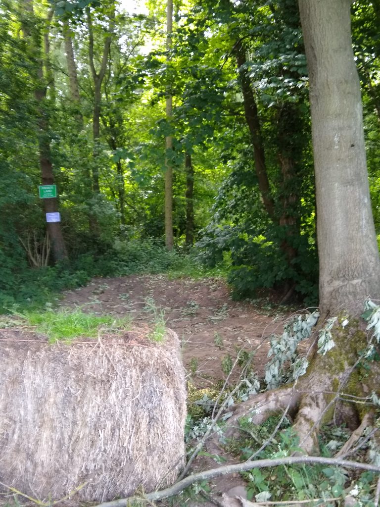
Following a request by the Public Rights of Way Officer at North Yorkshire County Council, the signs at either end of the unsurfaced section of Bedlam Lane (U8086/9/50) have now been removed by the landowner.
Bedlam Lane West End June 2nd 2020
How do I use the map?
This map is interactive. You can move and re-scale it using the various controls within the viewport.
Click/tap the map and drag to move the map around within the viewport as required.
Zoom in and out using the +- controls in the top left, pinch in/out or roll the mouse wheel when pointing within the map area.
Click/tap a marker, line or shape for further information in a popup window. If any marker, line or shape has an image, those images are displayed in a gallery at the bottom of the map. Select an image from the gallery and its marker will popup to indicate its location. The gallery is only displayed when one or more marker, line or shape with an image is within the map viewport.
Select the four corners icon in the top left to expand the map to full screen.
Select the tiles icon in the top right to select a different base map from the popup list. There are a number of base map options available.
Some maps also have layer switches that allow you to show or hide markers, lines or shapes. If a map has this feature, the layers and their switches are listed below the base maps. This feature enables markers, lines and shapes to be individually removed to make a map more readable.
Select the target icon in the bottom right to locate yourself with a marker. This feature will only work if your device has a GPS service and that service is currently active.
Can I download map data?
Yes. Select Details in the map header. A panel will overlay the right side of the map viewport, containing a file format drop-down list and a Download link. Select the required file format from the drop-down list and select the Download link. You will be prompted as to what you wish to do with the file.
The file will contain all of the waypoints for all of the currently visible markers, lines and shapes. You can control which markers, lines and shapes to include in the download file by switching the respective layers on or off. Select the tiles icon in the top right of the map viewport (close this panel first) to see the layers available below the list of base maps.
Whilst the panel is open, select More Details to display the map on a separate page. There is also an option to download map data on this page.
Close the panel by selecting the X in the top left corner of the panel.
North Yorkshire Connect Community Directory (NY Connect) is an online resource for people of all ages, helping them to find out about local activities, services, advice and guidance that is relevant, reliable and accessible 24 hours a day 7 days a week. NY Connect is available here.
The directory has around 7000 entries that people looking for local services and support can search either by keywords, postcode, area, or by using the category menu. Changes have been made to the community directory so that it can also be used by residents looking for support services during the Coronavirus (Covid-19) outbreak.
North Yorkshire County Council have opened more of their household waste recycling centres (HWRCs) recently. The HWRC at Dallamires Lane is Ripon is the latest to open. The site at Penny Pot Lane in Harrogate has been open for several weeks but the HWRC off Wetherby Road in Harrogate is still closed.
You can visit the two open sites from 8.30am to 5pm every day of the week (including bank holidays).
A quick reminder that Citizens Advice Craven & Harrogate Districts (CACHD) is up and running and able to provide help and support to everyone who needs it. Although they have had to close their face to face interviews for now, their staff and volunteers are working from home providing help and support over the phone and by email to almost as many people as they did before lockdown. Their services now are:
Over these past weeks, the majority of us have been required to stay home. How lucky we are, that not only are our homes in lovely countryside but, as the lockdown has demonstrated, we are part of a wonderful community.
Early in March, just before lockdown, we set out to contact every village household to reassure all, that whatever lockdown was going to mean, they would not be alone.
In Copgrove, being smaller than Staveley, through informal arrangements, residents have been able to help each other simply by looking out for their neighbours, keeping in contact, and sharing errands.
In Staveley, due partly to the greater number of households, we established a Buddy Scheme. Through the scheme, volunteer ‘helper/buddies’ from less restricted households were allocated to households who requested help and needed to strictly isolate. Some buddies were on stand-by to step in and help where and when situations and personal circumstances changed.
Buddies have cheerfully multi-tasked : picked up shopping, phoned for friendly chats, helped with pets, picked up supplies and medicines and provided information about local home deliveries for their neighbours, for long established and for new friends.
To all those who have offered help and friendship and especially to those who continue to provide it: A BIG THANK YOU from the community. However, we do not know what challenges the next few months will bring. Whatever they are, you and your household will not be alone. If you are self-isolating, require shielding support, a buddy or other help, PLEASE GET IN TOUCH.
Likewise, for anyone who is finding every day is too like the day before and staying home means little human contact or you are very new to the village do PLEASE GET IN TOUCH. You are not the only one and we are happy to coordinate the exchange of phone numbers with a view to creating even more new friendships within the villages, our home.
Description: 2 signs indicating entry to Copgrove, 1 on Wath Lane and 1 on Apron Lane.
Estimated Value: £710
Acquisition: Purchased in November 2020 and installed in February 2021.
Locations:
Wath Lane – Grid Reference:
Apron Lane – Grid Reference:
Recreation Field
Description: Enclosed field of public open space with a fenced children’s play area and small football pitch.
Location: Arkendale Road, Staveley. Grid Reference: SE
Rented From: Staveley Relief in Need Charity Rental Fee: £70 per annum
Allotments
Description: 2 allotment plots leased annually to local residents.
Location: Arkendale Road, Staveley. Grid Reference: SE
Rented From: Harrogate Borough Council Rental Fee: £40 per annum per site Lease Agreement
Posts & Chains
Description: A row of posts and chains along the edge of the village green west and the unmade road in front of the Royal Oak pub, acting as a barrier to prevent car parking on the green.
Location: Village Green West, Main Street, Staveley. Grid Reference: SE 363 627
Acquisition
Date: Not known Cost: £665
Current Use: Boundary fence
Notice Boards
Description: 3 village notice boards at various locations around the two villages.
Total Estimated Value: £1,425
Notice Boards 1 and 2
Location: Village Green East, Main Street, Staveley. Grid Reference: SE 366 627
Estimated Value: £950
Acquisition: 1997 and 2005/6
Key Holder(s): Bill Kirkpatrick, Neil Horton
Notice Board 3
Location: Start of St. Mongah’s Lane, Copgrove. Grid Reference: SE 345 632
Estimated Value: £475
Acquisition: 2002
Key Holder(s): Peter Edwards
Safety Barrier
Description: Safety barrier alongside the pull-in in front of the primary school. The Parish Council financed the barrier following the withdrawal of funds by North Yorkshire County Council.
Location: In front of primary school, Minskip Road, Staveley. Grid Reference: SE 366 628
Acquisition
Date: November 2011 Cost: £550
Current Use: Public safety barrier
Childrens Playground
Description: Childrens Playground, located on the recreation field comprising the following equipment items:
Wicksteed Whirly Bird
Record Cradle Swings
Record Flat Seat Swings
Hags Multi Pondo
Play and Leisure Multi Unit
Play and Leisure Fish Spring Mobile
Ledon Car Spring Mobile
Bench
Fencing and Gates
The playground is inspected annually by RoSPA and four times per year by a local specialist contractor. It is also visually inspected weekly by a team of local volunteers and stands on land rented annually from the Staveley Relief in Need Charity.
More information about the development of the childrens play area is available here. Maintenance of the playground is one of the Parish Council’s ongoing projects. Progress on the project can be seen by selecting the Children’s Play Area project page.
Location: Arkendale Road, Staveley. Grid Reference: SE 366 625
Acquisition: Adopted .
Estimated Value: £12,000
Bus Shelter
Description: Coated steel frame, clear screen shelter with 4 seats
Location: On village green east, Main Street, Staveley. Grid Reference: SE 366 627
Acquisition: January 2012. Purchased by the Parish Council, thanks to a donation from Abacus, a local employer based at Jubilee Court, Copgrove.
Description: Ex BT telephone box, now home to the village public defibrillator unit. The phobe box is a K6, designed by Sir Giles Gilbert Scott in 1936 and introduced to celebrate the King George V Silver Jubilee. It was probably installed under the ‘Jubilee Concession’, which meant kiosks were installed in every town and village with a Post Office. The K6 was 80 years old in 2016.
Location: Opposite the village green east, Main Street, Staveley. Grid Reference: SE 366 627
Acquisition: Phone box purchased from BT in May 2016 for a nominal sum of £1. The defibrillator was purchased from Wel Medical Ltd. and installed in June 2016.
Cost: £1,800 Current Valuation: Defibrillator £1,800. Replacement cost of K6 approx £2,500 plus delivery and installation.
Further Information:The defibrillator is checked weekly by the local Community First Responders coordinator. See Community First Responders for more details on how to use the unit.
Wooden Benches
Description: 5 wooden benches at various locations around the two villages.
Estimated Value: £1,900 for benches 1 – 4
Bench No. 1
Location: Wath Lane, Staveley. Grid Reference: SE 359 625
Acquisition: 1995
Bench No. 2
Location: Village Green West, Staveley. Grid Reference: SE 363 627
Acquisition: 1995
Bench No. 3
Location: Village Green West, Staveley. Grid Reference: SE 363 627
Acquisition: 1995
Bench No. 4
Location: Main Street, Staveley. Grid Reference: SE 365 627
Acquisition: 1995
Bench No.5
This seat was removed in 2020.
Location: Arkendale Road, Staveley. Grid Reference: SE 368 624
Bench No.6
Location: Open space on St. Mongah’s Lane, Copgrove. Grid Reference: SE 345 633
Estimated Value: £475
Acquisition: 2002
Stone Bench
Description: Wooden bench set within a stone surround.
Location: Junction of Main Street, Minskip Road and Arkendale Road, Staveley. Grid Reference: SE 366 627
Acquisition:
Estimated Value: £2,375
From the Archive: The seat when new in 1990
The Pinfold
Description: An animal pound where stray livestock were impounded. Animals were kept in a dedicated enclosure, until claimed by their owners, or sold to cover the costs of impounding. The term pinfoldis saxon in origin and common in the north of England. A village pound was a feature of most English medieval villages.
Location: Arkendale Road, Staveley. Size: approx 250 sq mt including the adjacent land. Grid Reference: SE 367 626
Acquisition: Erected in 1832 by public subscription and restored in 1986. Date: Not known Cost: £20,470 Current Valuation: £20,470
Current Use: Public amenity
Further Information: In 2012, thanks to an initiative by Staveley resident Ken Barker, a rose garden was planted in land next to the Pinfold to commemorate the Queen’s Diamond Jubilee. In 2019 a new gate to the Pinfold was installed by D.Hargreaves (Blacksmith) of The Forge, Coneythorpe.
Village Green East
Description: Former allotment site, purchased from the estate of F.L. Knowlson. A copy of the deed of conveyance is available here.
Location: Junction of Main Street, Minskip Road and Arkendale Road, Staveley. Size: Grid Reference: SE 366 627
Acquisition
Date: 2nd September 1986 Cost: £750 Current Valuation: £750
Current Use: Public open space
From the Archive: Oak Tree Planting
Village Green West
Description: Triangle of land registered to the Parish Council under Section 3 of the Commons Registration Act 1965 when no evidence of ownership was offered to the Commissioner at a hearing in Harrogate on 31st October 1973. A copy of the decision notice is available here.
Location: In front of the Royal Oak pub Main Street, Staveley Size: Grid Reference: SE 363 627
Acquisition
Date: 9th November 1973 Cost: £0 Current Valuation: